 |
| Heavy surf and dark clouds in Luquillo, P.R., signaled Hurricane Irma’s approach on Wednesday. Credit Ricardo Arduengo/Agence France-Presse — Getty Images |
Jose, currently a tropical storm, trails behind in the mid-Atlantic. And early Wednesday, a coalescing weather system in the southwestern Gulf of Mexico became tropical storm Katia — the fourth named storm in two weeks.
What’s going on?
Hurricane experts say that the formation of several storms in rapid succession is not uncommon, especially in August, September and October, the most active months of the six-month hurricane season.
“This is the peak,” said Gerry Bell, the lead seasonal hurricane forecaster with the Climate Prediction Center, a part of the National Oceanic and Atmospheric Administration. “This is when 95 percent of hurricanes and major hurricanes form.”
As to whether climate change has somehow made this year worse, the links between climate change and hurricane activity are complex and there are still many uncertainties.
Part of the problem, scientists say, is that there are just not that many storms: A dozen or so each year over the decades that good records have been kept do not form a huge data set to work with.
Some climate change impacts seem more certain than others. As the planet warms the atmosphere can hold more moisture, so hurricanes, like other rainstorms, could be expected to produce more rain on average than in the past. And as sea level rises, the impact of storm surges from hurricanes would be expected to worsen, because the surges are on top of a higher baseline.
Dr. Bell and his team at NOAA had forecast that this season would be a busy one, and that is how it is playing out, he said.
“With above normal seasons, you have even more activity mainly in August through October,” he said. “We’re seeing the activity we predicted.”
Since the season began on June 1 there have been 12 named storms, four of which strengthened into hurricanes, with maximum sustained winds above 73 miles per hour. Jose and Katia may well reach hurricane strength in the next few days.
 |
|
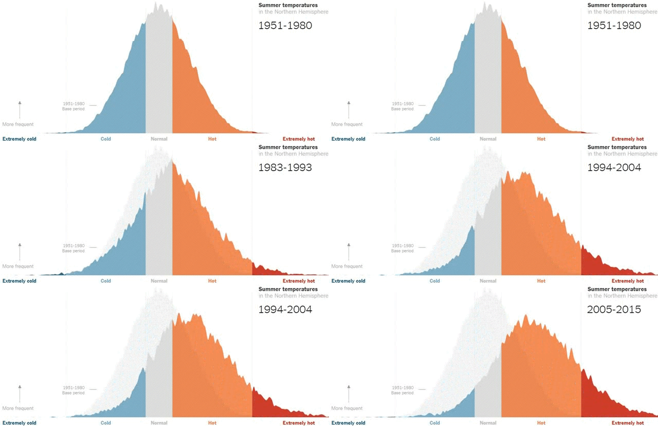
Summer temperatures have shifted toward more extreme heat over the past several decades.
|
Of the four hurricanes, Harvey and Irma are considered major, of Category 3 or higher, with winds above 110 m.p.h.
The Climate Prediction Center’s forecast, which was updated in August, predicted 14 to 19 named storms and five to nine hurricanes, including two to five major ones.
Dr. Bell said that in the late summer and early fall, conditions in the tropical Atlantic off Africa become just right for cyclonic storms to form. Among those conditions, he said, are warming waters, which fuel the growth of storms, and a relative lack of abrupt wind shifts, called wind shear, that tend to disrupt storm formation.
“There’s a whole combination of conditions that come together,” he said.
Storms that form in the Gulf of Mexico, as Katia did this week, are also not uncommon, Dr. Bell said.
Dr. Bell said his group does not consider climate change in developing its forecasts.
Instead, he said, they consider longer-term cycles of hurricane activity based on a naturally occurring climate pattern called the Atlantic multidecadal oscillation, which affects ocean surface temperatures over 25 to 40 years.
“We’ve been in an active era since 1995,” Dr. Bell said, as ocean temperatures have been generally higher. But from 1971 to 1994, he said, temperatures were generally lower, and hurricane seasons were quieter.
Links
- The Relationship Between Hurricanes and Climate ChangeHow Does Harvey Compare With Hurricane Katrina? Here’s What We Know
- Why Hurricane Irma Could Hurt, a Lot: Much Lies in Harm’s Way
- It’s Not Your Imagination. Summers Are Getting Hotter.
- A ‘500-Year Flood’ Could Happen Again Sooner Than You Think. Here’s Why.
- Alaska’s Permafrost Is Thawing
- Miles of Ice Collapsing Into the Sea

No comments :
Post a Comment