|
|
Spring is set to be a warm, wet affair, the BOM says.
(Supplied: Jenita Enevoldsen) |
|
Key Points
|
"Virtually all of eastern Australia is looking wet," the BOM's head of operational climate services Andrew Watkins said.
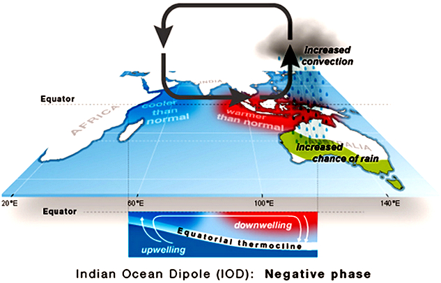
"With a negative Indian Ocean Dipole, we've got warm ocean temperatures near Western Australia, and that's pumping a lot more cloud and moisture across the continent and giving wetter than average conditions."

|
|
Above average rainfall is predicted throughout spring for the eastern two thirds of the country. (Supplied: Bureau of Meteorology) |
"We have some signs that we could be heading towards La Niña, though the forecasting models have been backing off a little bit of late," Dr Watkins said.
"That said, we do have warm water to the north of Australia and slightly cooler water off South America."Typically, even if we don't get to La Niña levels, that would help enhance rainfall in parts of eastern Australia."

|
|
The major climate drivers over the Pacific Ocean are in neutral.
(Supplied: Bureau of Meteorology)
|
Maximum temperatures through spring are likely to be above average for the northern tropics and the far south-east, while below average daytime temperatures are more likely for other areas of southern Australia and up into southern Queensland.

|
|
Maximum temperatures in spring are predicted to be higher than average across the north and the far south. (Supplied: Bureau of Meteorology) |
The soggy spring follows on from a wet winter in much of the country, particularly in south-west Western Australia.

|
|
Overnight temperatures are expected to be higher than average across almost all of the country. (Supplied: Bureau of Meteorology) |
"In the south-west, they've had a good old-fashioned winter with a continuing series of cold fronts bringing pretty consistent rainfall, particularly during June and July.
"That's keeping things fairly wet in those areas and the crops are going gangbusters."

|
|
It's shaping up to be a wet spring. (Supplied: Mat Brown)
|
Across tropical Northern Australia, it has been very warm through winter, with Darwin having its earliest 35-degree day on record.
"Australia's average winter temperature is also expected to be one of the 10 warmest on record — as much as it hasn't felt it at times, particularly in the south," Dr Watkins said.
Typically during a negative Indian Ocean Dipole, Australia sees cooler than average temperatures, but the BOM says Australia's temperature and rainfall variability are also influenced by global warming.

|
|
A negative phase of the IOD can increase rainfall across parts of Australia. (Supplied: Bureau of Meteorology) |
Despite the warm winter, alpine regions have had a close-to-average snow season, with snow depths at the benchmark Spencers Creek gauge peaking at 183.6 centimetres on of July 29, slightly below the long-term maximum snow depth of about 195cm.
"Not a bad ski season if you can get there," Dr Watkins said.
"It's fairly typical for a negative Indian Ocean Dipole.
"But also, we've had negative Southern Annular Mode at times, so our weather systems have been that bit further north more generally, and that does typically give you more snow cover."
Links
- BOM: Climate outlook overview (26 August 2021)
- BOM: Wet and warm spring for eastern Australia
- Experts warn wetter seasons risk grassfires alongside growth
- Has it really been that cold this winter or are we just getting soft?
- More wet weather on the way as BOM declares negative IOD
- (AU) Troubling Detail In Aussie Weather Data
- (AU) 2020 Annual Climate Statement - Bureau of Meteorology
- How The Weather Gets Weaponized In Climate Change Messaging

No comments:
Post a Comment