|
|
With this much rain around many roads will be flooded. Check before
heading out and do not drive through flood waters.
(ABC News: Jessica Moran)
|
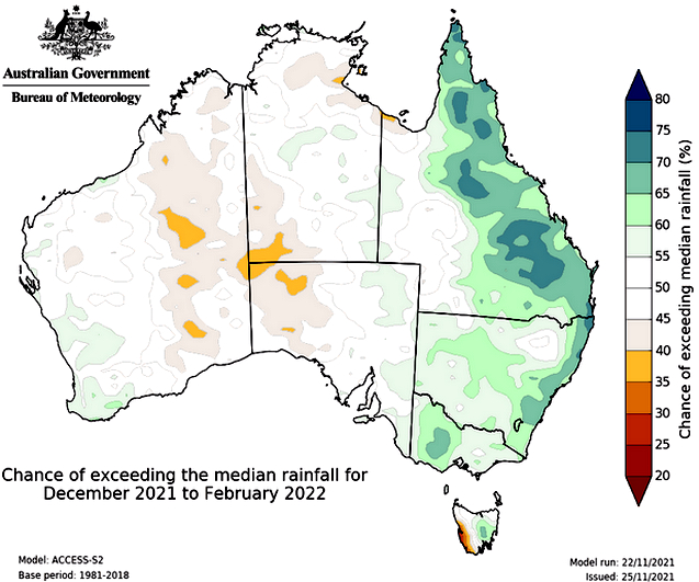
But with the climate driver to the west, the negative Indian Ocean Dipole, dying out, the centre is expecting a fairly normal summer in terms of rainfall.
Youtube Summer 2021-2022 climate and water outlook, issued 25 November 2021
While it might not end up being the wettest summer on record for Australia as a whole, with many catchments around the country already primed, it won't take much to trigger flooding this summer.
What is La Niña?

|
|
La Niña has just been declared, but what is it and what does it
mean for our weather? Read more
|
"Any additional rain on our already-wet landscape will increase the flood risk for eastern Australia this summer."

|
|
This summer is expected to be wetter than average for parts of the east but relatively normal through the centre. (Supplied: Bureau of Meteorology) |
In New South Wales, the dams are overflowing.
According to Tony Webber from Water New South Wales, it is a dramatic turnaround in water security from the worst years of the drought.
"That was only the end of the summer of 2019/2020," he says.
Many of the dams that were empty or nearly empty are now overflowing.
"Keepit Dam on the Namoi — that's now at capacity and spilling into the Namoi River — was dry for 14 months. Burrendong — that's at 128 per cent, but fell to 1.5 per cent," Mr Webber says.

|
|
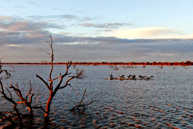
Pelicans at Lake Pamamaroo are among the dozens of species
benefiting from floodwaters that arrived in April.
(ABC News: Niall Lenihan) |
The turnaround has certainly been fantastic for water supply but it's obviously not all good news.
"The flooding is certainly most regrettable and the damage to the crops across many areas of the state at harvest time is quite heartbreaking for not just the farmers but everybody across the region," Mr Webber says.
"But in the longer term, the water security that we will have for communities, for agriculture, for the environment, is probably the best we've seen in at least a decade."
Keeping up with the flows if this kind of rain keeps up is going to be an ongoing challenge.
"Given that the majority of these storages that are at or about capacity, it'll just be an ongoing operational pattern that we've been in for weeks, if not months," he says.
"Waiting for a window between the rain events to lower the storage so that we're in a position to try to capture as much of the follow-up rain event on a wet catchment into a dam that's near capacity and releasing into rivers that are very high."

|
|
Copeton Dam — the biggest in the New England North West — spills
for the first time in nine years. (Supplied: Joe Varani) |
Murray-Darling Basin awash
Given that NSW makes up a large proportion of the catchment, it is therefore not a huge surprise that the Murray-Darling Basin is also awash.
According to the Murray-Darling Basin Authority executive director of river management, Andrew Kremor, the Murray-Darling Basin storages have already surpassed 2016 levels to reach 93 per cent.
"All this extra water in the system means flows into South Australia have also doubled in 12 months," he says.
"This time last year they were around 17GL a day and were around 34GL a few days ago," he said.
Flowing on, South Australia's water stores have also seen an increase in inflows this year.
"Natural inflow from winter rains have been higher this year when compared to the previous three years, largely influenced by high rainfall in July," according to a spokesperson from SA Water.
SA Water's reservoirs are currently sitting around 73 per cent — average for this time of year.
Even more dramatically, Western Australia has also seen a big uptick in its water stores thanks to plenty of winter rain — up to 62.1 per cent of capacity from just 27.2 per cent last year.

|
|
This is the first time since 2016 there has been enough water to
open the gates between Lake Pamamaroo and Lake Menindee (pictured).
(ABC News: Nathan Morris) |
More to come in Queensland
Overall, Queensland's water stores are up from 47.6 per cent this time last year to 54.4 per cent and the SEQ water grid is sitting at 55.5 per cent.

|
|
Queensland has certainly been getting some heavy rain but it is
taking a while for the water to trickle through to the dams.
(ABC News: Alice Pavlovic) |
Aside from the rain, the first cyclone of the season has already burst into being and more than average are expected this year.
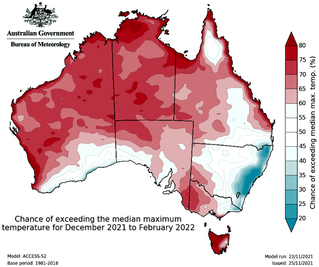
High overnight temperatures could also lead to gruelling heatwaves.
Summer fire outlook
Just because it is wet in one region does not prevent fires in another.
This year's bushfire outlook suggests a below average risk for parts of the NSW coast but above average for the interior.

|
|
Parts of the east coast might be expecting below normal fire
potential this year but fire is still an above normal risk for parts
of the west and inland NSW.
(Supplied: AFAC) |
Likewise in WA grass growth is up and above average temperatures are also expected to help dry things out.
As always, a normal fire risk for the rest of the country does not rule out fire. A normal Australian summer has fires.
- Get used to it, there's more rain to come before drenched east coast dries out
- Copeton Dam in northern New South Wales fills for first time in almost a decade
- La Niña has just been declared, but what is it and what does it mean for our weather?
- (AU The Conversation) Climate Change Is Likely Driving A Drier Southern Australia – So Why Are We Having Such A Wet Year?
- Explainer: El Niño and La Niña
- A wet winter, a soggy spring: what is the negative Indian Ocean Dipole, and why is it so important?
- La Niña is here, says BOM, so prepare for a wet summer in the east
- Floods and cyclones on the cards this severe weather season, BOM says
- La Niña has been declared. Why should we care?
- What is the meaning of La Niña and how will the weather event affect Australia’s summer?
- Climate change is likely driving a drier southern Australia – so why are we having such a wet year?
- Farmers on knife edge over La Nina


No comments :
Post a Comment