|
|
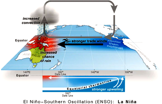
During a La Niña there are warmer than average waters
in the western Pacific near Australia and cooler than
average in the east. (Supplied: NOAA October 2021)
|
One of these giant eddies is called the Walker Circulation.
The Walker Circulation strides the Pacific Ocean, rising in the west in the warm waters near Australia, pushing up and over the Pacific and descending near South America before racing back across the Pacific Ocean to form the trade winds.

|
|
Under normal conditions the Walker Circulation drives the
trade winds across from the east to the west of the
Pacific. (Supplied: Bureau of Meteorology)
|
The western Pacific is even warmer than usual, the trade winds are stronger and all this moist energetic air is pushed onto Australia.

|
|
When there is a La Nina the Walker Circulation intensifies
bringing wet and warm conditions to Australia. (Supplied: Bureau of Meteorology) |
La Niña is therefore typically associated with wetter than average conditions for northern and eastern Australia, particularly in winter, spring and early summer.

|
|
La Niña events are typically associated with above average
rainfall for northern and eastern Australia. (Supplied: Adobe Stock)
|
With the air now rising near South America and falling over the cooler-than-average oceans near Australia, less moisture is available and lift is discouraged, often resulting in drier than average conditions for northern and eastern Australia.

|
|
When there is an El Nino the Walker Circulation is reversed
and downward pushing air brings dry conditions to
Australia.(Supplied: Bureau of Meteorology)
|
Together La Niña and El Niño are often referred to as the El Niño Southern Oscillation or ENSO.
The name El Niño was coined by South American fishermen in the 1600's who noticed unusually warm waters that often peaked around Christmas time.
They named the phenomena after 'El Niño de Navidad' after the Christ Child.
This evolved into just El Niño, 'the boy' and La Niña, 'the girl' to describe the opposite phase.

|
|
'La Niña' is the the girl child of the Pacific who
brings flooding rains. (Supplied: Jenita Enevoldsen)
|
Or more boringly referred to as a Central Pacific El Niño.
This phase is when the air rises in the centre of the Pacific descending on both sides and discouraging rain.
What does La Niña mean for Australia?
Straight off the bat, no two La Niña events are exactly the same.
La Niña conditions don't cause any one individual downpour, rather they stack the underlying conditions full of moisture for when any individual weather event does come along.
The increased rainfall also results in increases in mosquito-borne diseases.
Big La Niña events of the past include the 1973 to 1976 La Niña, which was the longest sustained period of La Niña on record.
1974 still stands as Australia's wettest year on record and 1973 and 1975 also made the top five.

|
|
Brisbane's CBD was inundated in January 1974. (Royal Historical Society of Queensland)
|
More recently, 2010 to 2012 is notable for having two big La Niña summers in a row.
2010 and 2011 combined, resulted in the wettest 24 months on record.
Flooding was widespread from spring 2010 through to the end of summer 2011 — up and down the east coast.
Horror flash flooding washed away Grantham in South East Queensland's Lockyer Valley and Brisbane again went under water.

|
|
Lang Park under water during the 2011 floods. (Nearmap.com) |
This year's La Niña is again following on from one last year.
But thankfully this combination is not expected to be as extreme as these big events of the past.
How does La Niña impact the world?
La Niña typically also brings wetter than average conditions to the nations north of Australia in our summer.

|
|
La Niña has flow-on effects that impact rainfall in many
regions around the world. (Supplied: International Research Institute for Climate
and Society Columbia University)
|
A study published in Nature found ENSO may have had a role in 21 per cent of all civil conflicts between 1950 and 2004, and that new civil conflicts in the tropics were twice as likely to arise during El Niño years than La Niña.
La Niña and El Niño are not the only drivers
ENSO is only one of a set of climate systems that affect Australia.
The Indian Ocean Dipole (IOD) is the other main year-to-year driver that influences Australia.
It gained household notoriety recently after its persistent positive phase took most of the blame for the drought that culminated in the 2019/2020 fires.
But other drivers like the Southern Annular Mode (SAM), and the Madden Julian Oscillation (MJO), also play a part.

|
| These are just some of the climate influences on Australia as explained by the Bureau of Meteorology. (Supplied: Bureau of Meteorology) |
These drivers are happening on top of the backdrop of climate change, with seasonal changes and individual systems in the foreground.
It is a wonderfully complex world out there.
Links
- La Niña is here, says BOM, so prepare for a wet summer in the east
- Floods and cyclones on the cards this severe weather season, BOM says
- La Niña has been declared. Why should we care?
- What is the meaning of La Niña and how will the weather event affect Australia’s summer?
- Climate change is likely driving a drier southern Australia – so why are we having such a wet year?
- Farmers on knife edge over La Nina


No comments :
Post a Comment