
 |
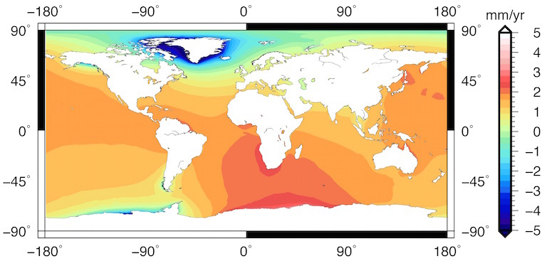
| The "fingerprints" of sea level rise revealed by a new computer modeling method that links changes in glaciers, ice sheets, and continental water storage to relative sea levels worldwide. Bluer areas, near Greenland, reflect a loss of ice mass, counterintuitively resulting in a sea level drop. In redder areas, sea levels are rising faster than global-mean rates. This map shows the linear trend in sea-level change and covers the period from 2003 to 2015. Image courtesy Surendra Adhikari, JPL. |
Even as computer models of a changing Earth grow ever more accurate, a major stumbling block remains: marrying models of ice, ocean, atmosphere, the solid Earth, and other components of the earth system to create a truly global picture.
A new modeling method takes a major step in that direction. Created by three members of NASA's Sea Level Change team, the new method allows researchers, for the first time, to weave high-resolution models of changes in individual glaciers into global models of relative sea level and solid Earth deformation, with great numerical accuracy and computational efficiency.
And because changes in ice mass leave their marks on Earth's gravitational and rotational fields—phenomena that generate so-called "sea level fingerprints"—the new model offers the possibility of precise, localized sea level forecasts.
One of the most fascinating and counter-intuitive features of these fingerprints is that sea level drops in the vicinity of a melting glacier, instead of rising as might be expected. The loss of ice mass reduces its gravitational attraction, and ocean water, no longer under its influence, migrates away. But far from the glacier, the water it has added to the ocean causes sea level to rise at a much greater rate.
With the new method, the loss of mass from a particular Antarctic outlet glacier, for example, could be tied directly to a sea level record at any tide gauge station around the globe.
"At Miami, in principle, we can isolate what fraction of observed sea level is due to what specific source—Jakobshavn Isbrae in Greenland, Pine Island Glacier in the West Antarctica, tidewater glaciers in Alaska, maybe others," said Surendra Adhikari, lead author of the paper announcing the discovery that was published on March 18. "(Another) application is that we can calculate sea level not only related to ice but also related to continental hydrology"—that is, the shifting of water mass on land through the action of storms, rivers, or even groundwater pumping.
The new modeling approach, discussed by Adhikari and co authors Erik Ivins and Eric Larour in the journal "Geoscientific Model Development," touches on much of the new technology and rapidly advancing knowledge that has transformed sea level research over the past two decades.
State-of-the-art simulation code originally dedicated to solving the ice-flow mechanics called the Ice Sheet System Model (ISSM; http://issm.jpl.nasa.gov/), also developed at JPL, served as the scaffolding upon which the new modeling method was built. But the heart of the new approach lies in the intricate mathematics – particularly the so-called Green's function formulation – of Earth's gravitational and rotational theory.
Green's function reveals the effects of a point of pressure on a sphere, such as a computer model of Earth, as it propagates away to its farthest point of influence—that is, 180 degrees away, on the opposite side of the sphere. The function allows modelers to trace the gradations of influence of such pressure: a strong indentation at the source, gradually weakening as it recedes.
The research team used an "unstructured mesh," a way of dividing up Earth's surface into manageable chunks that can be recombined by calculations to simulate changes—melting Antarctic glaciers, perhaps, or giant rainstorms that deposit large masses of water in South America.
Structured meshes have been used for years in global sea level modeling. But these have chunks of uniform size, like a huge fishing net thrown over the planet. With these traditional approaches it is virtually impossible to capture, for example, kilometer-scale glacial changes while also calculating global-scale relative sea level.
The new method keeps the larger chunks, or units, of mesh in places where deeply detailed simulations are unneeded—for instance, the middle of the Pacific Ocean. But in places where fine-grained detail is essential, such as jagged coastlines or the locations of melting glaciers, the model's mesh units can shrink to kilometer-scale sizes.
"This not only allows the model to capture subtle changes in glaciers and other small-scale phenomena within a global context, but also keeps computing time and the amount of data that must be fed into the model to manageable proportions," Adhikari said.
Adhikari's novel insight was to combine the unstructured mesh with a Green's function representation of relative sea level theory. This makes it possible to capture high-resolution glacial changes in the context of global-scale relative sea level. Larour, who leads about a dozen ISSM researchers from JPL and the University of California, Irvine, said, "the method opens up a new range of possibilities in terms of tightly coupling ice-flow and sea-level rise at a resolution compatible with regional scale projections."
The new model allows global projections of sea level change "while at the same time allowing the grounding line of the ice sheet to be fully connected to the modeled regional and global sea level position," Ivins said. "A natural by-product of the model is the ability to predict the full set of geodetic observables (3-D crustal motions, tilt, change in center of mass – center of figure offset, J2, and variations in earth rotation, absolute sea-level, gravity anomaly etc.) that NASA currently is heavily invested in."
Links
No comments :
Post a Comment