A
general view of a Taiyuan New Energy Co wind farm, during an organised
media tour, in Jiuquan, Gansu province, China October 17, 2024.
REUTERS/Tingshu Wang/File Photo
BEIJING: China says it will develop a package
of major projects to tackle climate change as it moves to bring its
carbon dioxide emissions to a peak before 2030 and become carbon neutral
by 2060.
The
world's largest producer of climate-warming greenhouse gas said it
would develop new offshore wind farms and accelerate the construction of
"new energy bases" across its vast desert areas, the National
Development and Reform Commission, the country's economic planner, said
in an official report published on Wednesday.
"China will actively and prudently work towards peaking carbon emissions and achieving carbon neutrality," the report read.
Among the proposed projects cited in the report by the state planning agency was a controversial hydropower facility on the Yarlung Tsangpo river in Tibet, which has raised concerns in India about its potential impact on downstream water flows.
It
also said it would develop a direct power transmission route connecting
Tibet with Hong Kong, Macao and Guangdong in the southeast.
However,
coal will remain a key fuel, with the NDRC report saying the country
will continue to increase coal production and supply this year even as
it plans for trials of low-carbon technology at its coal-fired power
plants and to promote initiatives aimed at substituting fossil fuels
with renewables.
China has been struggling to strike a balance between fostering economic growth and meeting its environmental goals.
The
NDRC said the 3.4% reduction in the amount of carbon emissions per unit
of economic growth last year "fell short of expectations", blaming
rapid growth in energy consumption as well as extreme weather.
China is not expected to meet its five-year goal to bring carbon intensity down by 18% by the end of this year, and it has not yet announced an annual target for 2025.
It
will also struggle to meet a separate target to cut the amount of
energy consumed per unit of growth by 13.5% by the end of this year,
despite exceeding expectations with a 3.8% reduction last year, analysts
said.
"Despite
the world record expansion of renewables, an inconvenient truth is that
China's economy hasn't become much more energy efficient in recent
years," said Yao Zhe, global policy advisor with Greenpeace in Beijing.
Liz Ritchie-Tyo Professor of Atmospheric Sciences, Monash University
Andrew Dowdy Principal Research Scientist in Extreme Weather, The University of Melbourne
Hamish Ramsay
Principal Research Scientist, Environment, CSIRO
Cyclone Alfred has now been delayed, as the slow-moving system stalls
in warm seas off southeast Queensland.
Unfortunately, the expected slow
pace of the cyclone will bring even more rain to affected communities.
This is because it will linger for longer over the same location,
dumping more rain before it moves on. Alfred’s slowing means the huge waves triggered by the cyclone will last longer too, likely making coastal erosion and flooding worse.
Cyclone Alfred is unusual – the first cyclone in half a century to come this far south and make expected landfall.
When unusual disasters strike, people naturally want to know what
role climate change played – a process known as “climate attribution”.
Unfortunately, this process takes time if you want details on a specific
event.
We can’t yet say if Alfred’s unusual path and slow speed are linked to climate change. But climate change is
driving very clear trends which can load the dice for more intense
cyclones arriving in subtropical regions. These include the warm waters
which fuel cyclones spreading further south, and cyclones dumping more
rain than they used to.
So, let’s unpick what’s driving Cyclone Alfred’s behaviour – including the potential role of climate change.
A Bureau of Meteorology update on Cyclone Alfred dated Thursday, March 6.
Not necessarily climate linked: Alfred’s southerly path
Many cyclones make it as far south as Brisbane – but they’re nearly
all far out at sea. Weather patterns mean most cyclones heading south
are diverted to the east, where remnants can hit New Zealand as large
extratropical storms.
The fact that Alfred is set to make landfall is very unusual. But we
can’t yet definitively say this is due to climate change. Cyclones are
steered by winds and weather patterns, and the Coral Sea’s complex
weather makes cyclone paths here very hard to predict.
Alfred’s abrupt westward shift is due to a large region of high
pressure to its south, which has pushed it directly towards heavily
populated areas of southeast Queensland and northern New South Wales.
These steering winds are not very strong, which is why Alfred is moving
slowly.
In 2014, researchers showed
cyclones are reaching their maximum intensity in areas further south in
the southern hemisphere and north in the northern hemisphere than they
used to. In 2021, researchers also found cyclones were reaching their maximum intensity closer to coasts, moving about 30 km closer per decade.
Climate link: Warmer seas
Cyclones typically need water temperatures of 26.5°C or more to form.
More than 90% of all extra heat trapped by greenhouse gas emissions is stored in the seas. The oceans are the hottest on record,
and records keep falling. But normal seasonal variability and shifting
ocean currents are still at work too, and we can get unusually warm
waters without climate change as a cause.
What we do know is that ocean temperatures around much of Australia have been unusually warm.
The northeastern Coral Sea, where Cyclone Alfred formed, experienced the fourth-hottest temperatures on record for February and the hottest on record for January.
In the Coral Sea, sea surface
temperatures were the fourth highest on record in February 2025 and the
highest on record in January 2025. This figure shows the trend over time
for February.Bureau of Meteorology, CC BY-NC-ND
We also know Australia’s southern waters are warming up too.
The energy available to power tropical cyclones in subtropical
regions has also increased in recent decades, due largely to rising
ocean temperatures.
Average sea surface temperatures in central and southern Queensland on Thursday March 6th. Point Danger is on the Gold Coast.Bureau of Meteorology, CC BY-NC-ND
Climate link: Fewer cyclones but more likely to be intense
In the northern hemisphere, researchers have found a trend towards
fewer cyclones over time. But of those which do form, a higher
proportion are more intense.
It’s not fully clear if the same trend exists in the southern
hemisphere, though we are seeing fewer cyclones forming over time.
This summer, eight tropical cyclones have formed in Australian
waters. Six were classified as severe (category 3 and up). Historically,
Australia has experienced a higher proportion of category 1 and 2
cyclones, which bring weaker wind speeds.
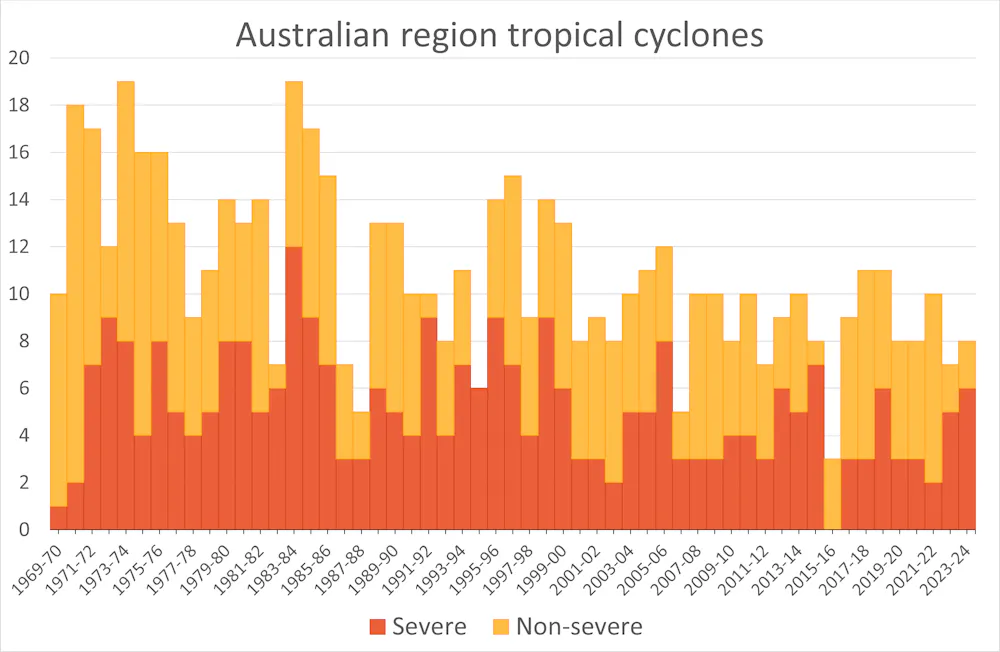
On average, we see about 11 cyclones form and 4-5 make landfall. There has been a downward trend in the number of cyclones forming in the Australian region in recent decades.
Fewer cyclones, but more likely to
be intense: this figure shows the number of severe (Category 3 and up)
and non-severe tropical cyclones (Category 1 and 2) since 1970/71.Bureau of Meteorology, CC BY-NC-ND
Climate link: Cyclones dumping more rain
The intensity of a cyclone refers to the speed of the wind and size of the wind-affected area.
But a cyclone’s rain field is also important. This refers to the area
of heavy rain produced by storms when they’re at cyclone intensity and
afterwards as they decay into tropical lows.
The rate of rainfall brought by cyclones in Australia isn’t necessarily increasing, but more cyclones are moving slowly, such as Alfred. This means more rain per cyclone, on average.
Rising ocean temperatures mean more water evaporates off the sea
surface, meaning forming cyclones can absorb more moisture and dump more
rain when it reaches land.
Why are cyclones slowing down? This is likely because air current
circulation in the tropics has weakened. This has a clear link to
climate change. Wind speeds have fallen 5 to 15%
in the tropics, depending on where you are in the world. It’s hard to
pinpoint the change clearly in our region, because the historic record
of cyclone tracks isn’t very long.
For every degree (°C) of warming, rainfall intensity increases 7%. This is well established. But newer research is showing the rate may actually be double this or even higher, as the process of condensation releases heat which can trigger more rain.
Clear climate link: Bigger storm surges due to sea level rise
When a cyclone is about to make landfall, its intense winds push up a
body of seawater ahead of it – the storm surge. In low lying areas,
this can spill out and flood streets.
Because climate change is causing baseline sea levels to rise, storm
surges can reach further inland. Sea-level rise will also make coastal
erosion more destructive.
Huge swells have forced beach closures ahead of Cyclone Alfred’s arrival.Jason O'Brien/AAP
What should we take from this?
We can’t say definitively that climate change is behind Cyclone Alfred’s unusual track.
But factors such as rising sea levels, slower cyclones and warmer
oceans are changing how cyclones behave and the damage they can do.
Over time, we can expect to see cyclones arriving in regions not
historically affected – and carrying more rain when they arrive.
Australian summer smashed temperature records yet again, fuelling
climate disasters around the country, while the weather bureau has
predicted a hot autumn.
A Sydneysider shelters in the shade at Bondi on a hot day in January. Credit: Dion Georgopoulos
The season was marked by bushfires in
Victoria and Tasmania, heatwaves that stretched from Sydney to Perth,
record-breaking deluges in tropical north Queensland, and marine
heatwaves that killed coral and fish around the entire continent.
Scientia
Professor Matthew England, a climate scientist at the University of
NSW, said climate change had profoundly altered Australian summers over
the past couple of decades.
“When I was a kid growing up, summer
was the season Australians looked forward to, but these days there’s a
collective trepidation about summer because it’s the season where the
worst climate extremes are playing out,” England said.
“It’s
the season that we’re most fearful or anxious about – what sort of
heatwaves will we have, what bushfire risks will come about, where will
the flooding rains be?”
There is more to come – the Bureau of
Meteorology’s long-range forecast for March to May shows a high
likelihood of warmer-than-average days and nights and an increased
chance of unusually hot days and nights across the country. Rainfall is
likely to be in the typical range for most of Australia, including NSW
and Victoria.
While the weather bureau will release a more
detailed climate summary next week, a spokesperson said summer had been
much warmer than usual for most of Australia.
Heating Australia
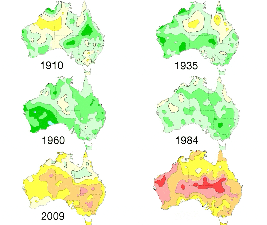
Average temperatures from 1910 to 2024. Bureau of Meteorology
“Every
state and territory had above-average daytime and night-time
temperatures,” the spokesperson said. “Parts of the west and some
central areas had their warmest summer on record.”
This comes after 2024 was confirmed as the hottest year on record globally, followed by news from Europe’s Copernicus Climate Change Service that January 2025 was the world’s hottest ever January.
For
Australia, it was the second-warmest January since records began in
1910, with BoM figures showing the average temperature sitting 2.15
degrees above the 1961-90 benchmark. It followed the third-warmest
December since 1910, with the national average temperature 1.88 degrees
above the long-term average.
An early morning walker exercises in Brighton-le-Sands ahead of a sweltering January summer day. Credit: Sam Mooy
The
highest daytime temperature of the summer anywhere in the country was
49.3 degrees at Geraldton Airport in the Mid West of Western Australia
on January 20, the weather bureau said. The hottest night-time
temperature of the summer was at Leinster Aero in WA, which was 34.8
degrees overnight on February 9.
Summer
was wetter than usual for parts of the country’s east and north-west,
but drier than average across parts of the country’s south and central
areas, including large parts of NSW and the Northern Territory and most
of Victoria. Large areas also had summer rainfall that was close to
average.
The monsoon did not reach Darwin until February 7, the latest since records began. The previous record was January 25 in 1973.
However,
the monsoon trough was established over Queensland from the end of
January and also briefly in northern WA. The coastal area between
Townsville and Ingham in Queensland had its highest February monthly
rainfall on record, with some areas receiving 1.5 metres of rain over three days, causing massive river flooding.
Flooding in Macknade in North Queensland in February. Credit: Nick Moir
The wettest day of the summer anywhere in the country was February 3 at Paluma Ivy Cottage in Queensland, which recorded 745.2mm in one day.
Australia
has had seven tropical cyclones in our region so far this season. On
February 14, Tropical Cyclone Zelia was the first of the season to cross
Australia’s mainland, causing high rainfall in the Pilbara region of
WA.
The extreme weather events and associated natural disasters
also included bushfires in Victoria and Tasmania, and a marine heatwave
that caused coral bleaching in the Great Barrier Reef and Ningaloo Reef in WA, the death of about 30,000 ocean fish off the Pilbara coast, and a mass mortality event in salmon farms in Tasmania.
A farmer and Country Fire Authority volunteer monitors the fire beside his property near the Grampians in December. Credit: Justin McManus
The Climate Council has released a heat map tool
revealing how Australian electorates would fare under a high-emissions
scenario leading to global warming of 4.4 degrees by 2100.
The
electorate of Parkes in north-western NSW would face 120 days a year
over 35 degrees by 2090, up from an average of 55 days now. In Sydney,
north shore electorate Bradfield would have 21 hot days, up from five,
while neighbouring Bennelong would increase from six to 23.
The
seat of Mallee in Victoria would have 58 days over 35 degrees by 2090,
up from 25. The Casey electorate in east Melbourne would increase from
three hot days to 14, while bayside Goldstein would increase from seven
to 20 hot days.
The hottest electorate in Queensland would be
Kennedy, with an increase from 110 days above 35 degrees on average to
214, while the electorate of Brisbane would face an increase in hot days
from two to 24, and hot nights above 25 degrees from one to 33.
Years of intense recurring marine heatwaves around Australia’s coast are causing the cyclone danger
zone to extend further south to take in Brisbane and northern NSW, with
scientists fearing that the tropical storms could one day even threaten
Sydney.
Not only is the range of tropical cyclones extending
north and south of the equator due to climate change, the storms are
expected to be more intense, carry more moisture and move more slowly,
causing them to dump more rain over the areas they hit.
In the
northern hemisphere hurricanes and typhoons are increasing the risk for
major cities such as New York, Boston and Tokyo, as the tropical zone
has increased its latitude by 1-2 degrees every decade for the past
several decades.
Professor Liz Ritchie, from Monash University and
the Australian Centre of Excellence for 21st Century Weather, said
there was evidence that cyclones were already moving further south in
Australia, and much clearer evidence they were moving further north in
the North Atlantic and the Pacific Northwest.
“There’s
an expectation that they will be able to move further south here, and
there are already some results that show that over the last five to 10
years, they have already started to move further south,” Ritchie said.
“That
could be a function of warmer sea surface temperatures or a function of
how we’ve recorded and tracked these things in the past … but they do
look like they’re moving further south both off our west coast and off
our east coast, as well as in both the South Pacific and the south
Indian Ocean.”
Tom Mortlock, head of climate analytics
Asia-Pacific at Aon and an adjunct fellow from the Climate Change
Research Centre at the University of NSW, said the trends for the past
60 years were unclear, but several climate models suggested a southward
shift would occur.
“There are projections that with a warming
ocean and a warming atmosphere, that we may see a higher chance of
cyclones tracking further south than we have done over the historical
period in the future,” he said.
A 2021 peer-reviewed article in Nature Geoscience found
that 21st-century tropical cyclones “will most probably occupy a
broader range of latitudes than those of the past 3 million years” with a
distinct poleward shift.
Historical tropical cyclone activity across Australia between 1981 and 2017. Credit: Geoscience Australia
On
Tuesday morning Cyclone Alfred was sitting about 500 kilometres to the
east of Brisbane and the Sunshine Coast as a category 2 system. The
Bureau of Meteorology expects it to gradually move south and then take a
sharp turn to the west to make landfall north of Brisbane from late
Thursday into Friday.
The
worst effects would be south of the cyclone in Brisbane, the Gold Coast
and the Northern Rivers, BoM said, including intense winds, rainfall
and coastal swells.
Scientists said if the cyclone hypothetically changed direction, it was possible for it to travel as far south as Sydney.
“We
actually have sea surface temperatures that are warm enough to sustain
tropical cyclones as far south as Sydney at the moment, which is
unusual,” Mortlock said.
Mortlock
said a cyclone would only form if ocean waters were about 26-27 degrees
and it would peter out unless there was also continued marine heat
along its path. Australia has a marine heatwave around most of its
coastline, a recurring phenomenon every summer for the most of the past
decade.
Ritchie said: “If Alfred happened to track down and didn’t
make landfall near Brisbane but came down towards Sydney, it could
potentially follow that little tongue of warm water and stay fairly
intense before it came inland. That is absolutely true but it’s not
going to happen [this time].”
A tropical cyclone is a low-pressure
system generated in the tropics that gets its energy from warm sea
surface temperatures, spins up and then releases that energy as it makes
landfall. It is the same type of storm as a hurricane or typhoon,
though it spins in opposite directions on either side of the equator.
Alfred
would be first tropical cyclone to impact NSW since Nancy in 1990.
Mortlock said tropical cyclones were usually downgraded by the time they
made landfall in southern Queensland or northern NSW, but the
ex-tropical cyclones or tropical storms were often “messier” with more
widespread impact.
Heating Australia
Average temperatures from 1910 to 2024. Bureau of Meteorology
Mortlock said there was also a clear and continuing trend over several decades for a decrease
in the number of cyclones making landfall on the Australian east coast,
bucking the global trend of more cyclones. However, he said the
cyclones that did hit the Australian continent were expected to be more
severe.
Ritchie said the risk of cyclones causing floods was
increasing because a warmer atmosphere could hold more water and the
storms tended to stay in one place for longer, dumping rain in one
location. She said this had occurred with Cyclone Jasper in December
2023.
“When we think of severity, we’re often talking about the
winds, but it’s one of the important changes that we seem to be already
seeing, is the amount of rainfall that can come out of these systems,”
Ritchie said.
Melting Antarctic ice is releasing cold, fresh water into the ocean, which is projected to cause the slowdown
Antarctic Circumpolar Current (in yellow). Climate models show the current could slow down 20% by 2050.Illustration: Dr Taimoor Sohail
In
a high emissions future, the world’s strongest ocean current could slow
down by 20% by 2050, further accelerating Antarctic ice sheet melting
and sea level rise, an Australian-led study has found.
The
Antarctic Circumpolar Current – a clockwise current more than four
times stronger than the Gulf Stream that links the Atlantic, Pacific and
Indian oceans – plays a critical role in the climate system by
influencing the uptake of heat and carbon dioxide in the ocean and
preventing warmer waters from reaching Antarctica.
Using
Australia’s fastest supercomputer and climate simulator, Gadi, located
at Access National Research Infrastructure in Canberra, the researchers
used climate models to analyse the impact of changing temperature, ice
melting and wind conditions on the Antarctic Circumpolar Current.
The results, published in Environmental Research Letters,
revealed a clear link between meltwater from Antarctic ice shelves and
circumpolar current slowdown, and comes less than a week after another paper anticipated a weakening in vital Atlantic Ocean currents.
What
they found suggested a “substantial reconfiguration of Southern Ocean
dynamics”, with “far-reaching impacts on global climate patterns,
oceanic heat distribution, and marine ecosystems”.
Co-author Assoc Prof Bishakhdatta Gayen, from the University of Melbourne, described the result as “quite alarming”.
He
explained that as melting Antarctic ice released cold, fresh water into
the ocean, this sank and spread towards the equator. That flow of fresh
water changed the density variation in the ocean, a key driver of
movement, causing the slowdown.
“The ocean is
extremely complex and finely balanced. If this current ‘engine’ breaks
down, there could be severe consequences, including more climate
variability, with greater extremes in certain regions, and accelerated
global warming due to a reduction in the ocean’s capacity to act as a
carbon sink,” Gayen said.
Sea ice near
Horseshoe Island in Antarctica. The drastic fall in sea ice coverage for
the the third year in a row has scientists concerned there may a
fundamental shift under way. Photograph: Anadolu Agency/Getty Images
Co-author and climate scientist Dr Taimoor
Sohail said the slowdown could lead to a “vicious cycle”, where more
warm water reaches the Antarctic shelf accelerating ice melting and
further weakening the current.
This could also
disrupt ecosystems and food webs, he said, as the oceanic current helps
to prevent invasive species – such as rafts of southern bull kelp – from
reaching the fragile continent, or redistributed them.
“Concerted
efforts to limit global warming – by reducing carbon emissions – will
limit Antarctic ice melting, averting the projected slowdown,” Sohail
said.
Dr Edward Doddridge, a physical
oceanographer at the University of Tasmania who was not involved with
the study, said it was significant and surprising, given previous
studies had indicated that the northern parts of the Antarctic
Circumpolar Current were accelerating due to ocean warming.
Doddridge
said it was important to investigate the ways that ocean currents might
change, given more than 90% of the extra heat trapped on Earth had been
stored in the oceans, which then moved the heat around in ways that
affected the climate and weather in different places around the world.
Monash
University climate scientist Dr Ariaan Purich, who was not involved
with the paper, said dramatic changes were already under way in the
oceans around Antarctica.
Fresh water stored in
Antarctic ice sheets and shelves was melting at an accelerating rate,
she said, and every summer since 2022 – for the first time in recorded
history – the extent of sea ice surrounding the continent had dropped
below 2m square kilometres.
“We need to know
what the ocean is doing and how much heat and carbon the ocean is taking
up so that we can better project the climate that we’re experiencing
here on land in Australia, and that we can better adapt for that
climate,” she said.
It's no secret that Australia, like the rest of the world, is heating up.
So
much so that, by 2050, seven regions across the country are on track to
spend 90 days or more with temperatures over 35 degrees per year,
according to research from the Climate Council.
It released the
data ahead of the upcoming federal election, highlighting the
electorates most likely to experience a spike in extremely hot days if
current levels of action on climate change are maintained.
"Progress
is being made to cut climate pollution, but we need to pick up the
pace," Climate Council chief executive Amanda McKenzie said.
"As
Australians go to the polls, we must understand that the next
government's climate policies will determine the type of future our kids
experience."
Federal electorates facing the biggest increases in sweltering days
Grey, South Australia
27 more days over 35 degrees
The South Australian seat of Grey will experience 27 more days a
year over 35 degrees by 2090, making a total of 96 days a year.
This will include 19 days more over 40 degrees a year, up to
39.
By 2050, Grey will already see 87 days annually over 35, an
increase of 19 from now.
Grey includes the majority of SA outside of Adelaide,
including Port Lincoln, Whyalla, Port Augusta (pictured), and
Port Pirie, and its south border touches the Barossa Valley.
Attribution:
Getty
O'Connor, Western
Australia
28 more days over 35 degrees
O'Connor in Western Australia is set to experience 98
sweltering days over 35 by 2090 – an increase of 28 from
current levels – as well as 39 days over 40.
By 2050, it will have 90 days a year over 35 degrees, an
additional 20 days from now.
O'Connor spans a broad area across the state's south,
including Albany, Kalgoorlie, and Esperance.
Attribution:
iStock
Parkes, NSW
32 more days over 35 degrees
The NSW electorate of Parkes - physically the largest in the
state - will sweat through an additional 32 days over 35 by
2090, for a total of 87 annually.
It covers Broken Hill, Dubbo, Forbes and Parkes, and is one
of the state's poorer electorates.
The area will also see 21 days a year over 40 degrees by
2050, and 27 by 2090.
Attribution:
Getty
Flynn, Queensland
38 more days above 35 degrees
Flynn in south-east Queensland, a predominantly rural area, will
have 69 days a year above 35 degrees by 2090, an increase of 38.
It includes towns such as Biloela and Emerald, and swaths of
farming land.
Attribution:
Getty
Capricornia, Queensland
40 more days above 35 degrees
Capricornia, which borders Flynn, will have 40 more days
above 35 degrees by 2090, adding up to 77 days a year.
Home to the picturesque beach town Yeppoon, it also contains
vast amounts of native forest.
Attribution:
Getty
Maranoa, Queensland
43 more days above 35 degrees
Maranoa is Queensland's largest electorate, spanning towns
including Roma, Surat and Mitchell.
Its temperatures are forecast to reach over 35 degrees for
134 days a year in 2090, an increase of 43 from today's
figures.
In 2050, the electorate will have 120 days when the mercury
passes 35.
Attribution:
Getty Images/iStockphoto
Durack, Western Australia
48 more days above 35 degrees
Covering all of northern Western Australia, Durack is the
largest electorate in the whole of the country, reaching from
the coast to central Australia.
Its landscapes vary, from tropical coastal towns like Broome
to desert.
Durack will have 172 days a year above 35 degrees by 2050 and
186 days by 2090, increases of 34 and 48 respectively.
That means the electorate will experience temperatures of
above 35 degrees for around half the year in 25 years' time.
Attribution:
Getty
Leichhardt, Queensland
54 more days above 35 degrees
Home to tropical
paradises like Cairns and Port Douglas, Leichhardt in
Far-North Queensland is getting hotter.
It will have 98 days above 35 degrees by 2090, an increase of
54.
By 2050, places like Cairns will already be feeling the heat,
with 78 days a year above 35 degrees.
Attribution:
Getty Images/iStockphoto
Kennedy, Queensland
57 more days above 35 degrees
The seat of Kennedy in north Queensland is home to small towns
like Ingham and Innisfail, and tropical banana and mango crops.
The electorate is set to sweat through 167 days above 35 degrees
by 2090 and 146 days above 35 degrees by 2050 – increases of 57
and 36 respectively.
Attribution:
Getty Images/iStockphoto
Lingiari, Northern Territory
57 more days above 35 degrees
Coming in equal with Kennedy is Lingiari –Australia's poorest
electorate, with the largest town being Alice Springs.
Home to a large Indigenous population, Lingiari encompasses
all of the Northern Territory outside Darwin and its
surrounds.
The Climate Council says it is on track for 57 extra days
with the mercury hitting 35, for a yearly total of 188.
The area will also see 58 days a year above 40, an increase
of 33.
Attribution:
Getty Images/iStockphoto
Solomon, NT
132 more days above 35 degrees
The electorate of Solomon, which covers Darwin and its
surrounds, tops out the list.
According to the Climate Council data, it will spend 173 days
above 35 degrees by 2090, an increase of 132 from today's
levels.